Maps 2.0
On this website, you will find all the information about Maps 2.0 in the current development stage.
On this website, you will find all the information about Maps 2.0 in the current development stage.
- Most of our accidents happen at the delivery sites
( we hit bins, poles, barriers, fences, lamps etc. )
- Dealing with each little accident requires resources
( filling forms, investigation, phone calls, meetings, assessments... )
- I believe this app can make our journeys and reverses safer and because of that, save some of those resources by eliminating unnecessary accidents.
- - >
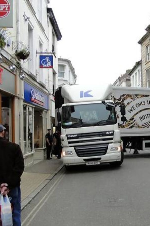
Martin Brower lorry, Barnstaple, United Kingdom
First I would like to provide some important details on how the project was developed.
For every new driver starting work with the company, taking new routes and deliveries can be stressful.
To minimize this stress and focus on safely reaching the destination, it's important to use available tools.
My project combines these tools into a single application, making it easier to prepare for a route.
The idea came to me while driving on the highway.
Route and delivery planning can be challenging, with concerns that taking a wrong turn, making a
navigation error, or encountering maneuvering difficulties at the destination could lead to
traffic disruptions, accidents, or issues for the company, which can result in additional costs.
That's why every driver in can use the tools available to them, such as:
- company maps
- other people bits of advice
- SatNav
- Google Street View
- Google Maps
- google images of my destination
etc...
Daily preparation that incorporates all these elements should lead to more efficient
journeys with fewer accidents.
This app is designed to help achieve that.
more....

One one day, when driving on M25 near London, I realized that I can make an application and connect all the
information together and make something that I call today “Maps 2.0 App"
I had the necessary knowledge and skills to do it, so I decided I will make it, and then I will try to introduce it to somebody at Martin Brower.
more....

In 2017, I shared my idea with Erik Welge ( General Manager, Martin Brower Basingstoke ) while creating a graphic project for him. Erik was impressed and decided that he will help me promote my project as soon as I show him how it is supposed to work.
A few weeks later he sent me an e-mail in which he encouraged me to take part in a Martin Brower competition: Shark Tank 2017 ( Global)
He sent the application form, which I prepared earlier along with the presentation of the idea ( https://youtu.be/I0vy2kMkSgU )
Unfortunately, although the answer was promised at the entry-level, even if the project would not go to further stages, we never received any.
Erik left the company and I was left alone. I've made more attempts to interest more people from MB Basingstoke by making a presentation of my software. I got very positive feedback from Leanne Giles ( Assistant Operations Manager ) and Chris Ham ( Senior Transport Shift Manager ), and later on loads of help from Karl Smith ( General Manager, Martin Brower Basingstoke ) who was very excited about this project.
Unfortunately, nobody else in Martin Brower UK was interested at this time.
Since last year I have a working prototype of my application. This is a fully working framework of the app that can be a great tool for Martin Brower or other logistic companies.
I just need a decision to proceed with this project.
more...
- ASP ( Active Server Pages ) *
- PHP ( Hypertext Preprocessor )
- MSSQL ( Microsoft SQL Server )
* so far several thousand lines of code :)
more....
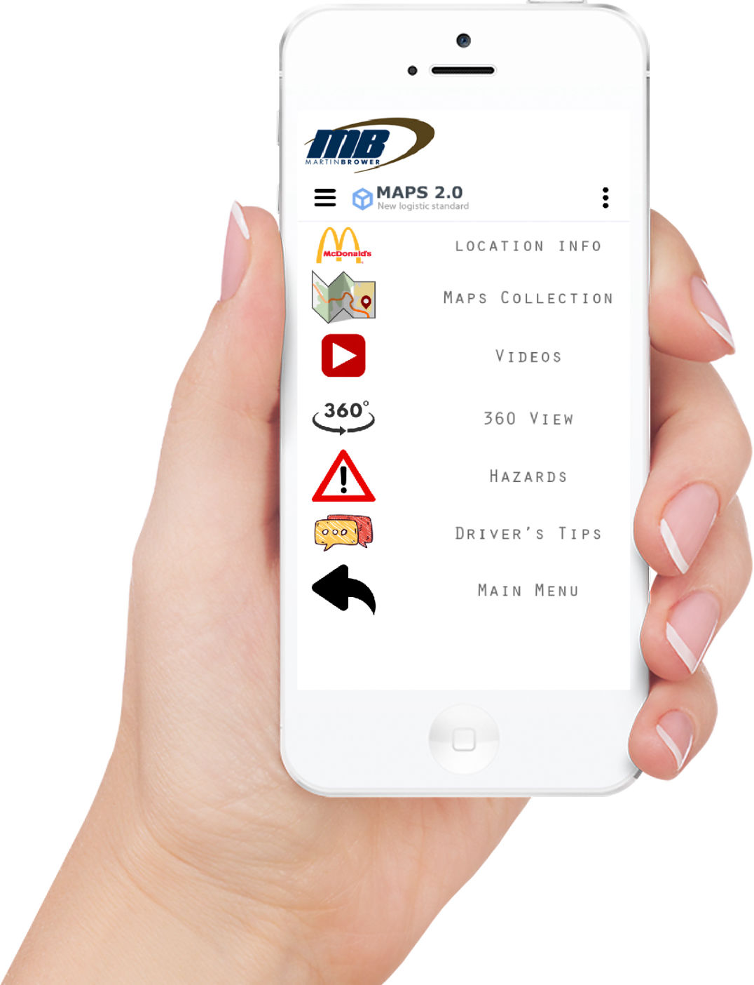
Maps 2.0 is a location database in a form of a web-based app, that can be used in the logistic sector as a helpful tool for delivery drivers.
At the beginning, each location is an address with basic information about the location ( POI* like restaurant, delivery destination ).
At this moment, each such entry can be expanded with extra information such as :
- digital maps ( scanned or created )
- full destination address information
- location in the form of Google Maps feature
- location in the form of Street View feature of the location
- photos of hazard points
- videos files from the location or reversing videos
- training videos or video comments
- user comments and other driver's tips about reversing methods at specific locations etc.
- 360 videos of the location ( future option )
All those pieces of information create a full database entry.
In the future, it can be expanded with additional functions.
The administrator adds them, but some functions such as comments, tips, and photos can be added by other users.
more...
Driver Mode - using Map 2.0 on mobile device with driver login
Administration Mode - adding new entry to data base on pc computer
Designed with Mobirise - Click here